


boucle Ligueux 250107

DDESLAN
User
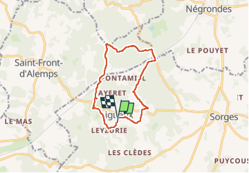

Length
11.3 km

Max alt
220 m

Uphill gradient
189 m
Km-Effort
13.9 km

Min alt
141 m

Downhill gradient
195 m
Boucle
No
Creation date :
2025-01-07 08:05:00.32
Updated on :
2025-01-20 15:46:50.382
3h00
Difficulty : Difficult

FREE GPS app for hiking
 SityTrail
IGN / Geographical institutes
SityTrail Plus
The world is yours!
About
Trail Walking of 11.3 km to be discovered at New Aquitaine, Dordogne, Sorges et Ligueux en Périgord. This trail is proposed by DDESLAN.
Positioning
Country:
France
Region :
New Aquitaine
Department/Province :
Dordogne
Municipality :
Sorges et Ligueux en Périgord
Location:
Ligueux
Start:(Dec)
Start:(UTM)
329036 ; 5019181 (31T) N.
Comments